Posts

Mt. Amuyao Barlig-Batad Traverse

Image
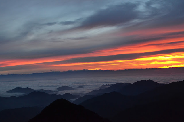
View from MT. Amuyao summit MT. AMUYAO ( BARLIG-BATAD TRAVERSE) Mountain Province and Ifugao Entry point: Sitio Macalana, Barlig, Mt. Province Exit point: Batad Junction, Banaue, Ifugao LLA: 17.0123N, 121.1297E, 2702 MASL Days required / Hours to summit: 3-4 days / 5-7 hours Good Morning Mt. Amuyao  From left : Ate Diane,Ate Joie,Kuya Vic,Kuya Rowel,Kuya Marc,Tito Anthony and Sir Ron Rabadon of TeamExtreme/GoROnAdventures (Tour Coordinator). Isang malamig na umaga ang sasalubong sa inyo sa summit ng Mt. Amuyao kung saan makikita mo ang tinatawag nilang Cloud Sandwich. Pat-yay Village Isang maliit na nayon kung saaan masisilayan nyo ang kagandahan ng Kabundukan at ang payak na pamumuhay ng mga naninirahan dito. Maari kayong magpahinga sa lugar na ito ngunit humingi muna maari ng permiso sa mga naninirahan dito, pagpapakita ng lubos na paggalang sa kanila. Marami ring mga bata ang makikita nyo dito at maari din kayong magbahagi ng mga

HiponSaBundok.Mountaineer goes to Mount Apo (Davao)!

Image
Mount Apo (Kidapawan) Mount Apo is a large solfataric , potentially active stratovolcano in the island of Mindanao , Philippines . With an elevation of 2,954 metres (9,692 ft) above sea level , it is the highest mountain in the Philippine Archipelago and is located between Davao City and Davao del Sur province in Region XI and Cotabato province in Region XII . The peak overlooks Davao City 45 kilometres (28 mi) to the northeast, Digos City 25 kilometres (16 mi) to the southeast, and Kidapawan City 20 kilometres (12 mi) to the west.(Wikipedia)... Sample Itinerary for Mt.Apo (Sta.cruz trail/Back trail). Day:0     1300start travel to kapatagan    1500 kapatagan ride habal2x going to jump off    1530 sta cruz trail jump off    1600 sitio tumpis (set camp)    1800 prepare dinner    1900 dinner    2100  lights off  Day:1     0300 wake up call and breakcamp    0330 early breakfast     0400 start trek to whitesand    0900 Camp 1     1200 l